|
Projekt
Artikel
Galerie
Experiment
3D-Modell
Grundlagen Geologische Karte Perspektivische Ansichten |
|
|
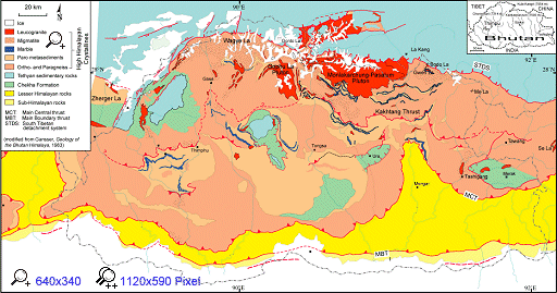
Geologische Karte von Bhutan (Djordje Grujic). Umgezeichnet nach
Bhargava (1995), Edwards et al. (in press),
Gansser (1983), Wu et al. (1998) und eigenen Beobachtungen.
Bhargava, O. N. (1995): The Bhutan Himalaya: a geological account.- Geological Survey of India, Special Publication, 39, 245 S. Edwards, M. A., Pêcher, A., Kidd, W. S. F., Burchfiel, B. C. & Royden, L. H. (in press): South Tibetan Detachment System (STDS) at Khula Kangri, Eastern Himalaya: a large area, shallow detachment stretching into Bhutan?- Journal of Geology. Gansser, A. (1983): Geology of the Bhutan Himalaya.- Denkschriften der Schweizerischen Naturforschenden Gesellschaft Basel, Birkhäuser Verlag, 96, 181 S. Wu Changde, Nelson, K. D., Wortman, G., Samson, S. D., Yue Yongjun, Juxiang, L., Kidd, W. S. F. & Edwards, M. A. (1998): Yadong cross structure and South Tibetan detachment in the east central Himalaya (89°-90°E).- Tectonics, 17, S. 28-45. |