
figure1.html (57 kB) |
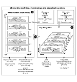
figure2.html (17 kB) |
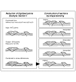
figure3.html (12 kB) |
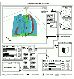
figure4.html (46 kB) |
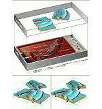
figure5.html (112 kB) |
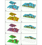
figure6.html (76 kB) |
Zbl. Geol. Paläont. Teil I, 1997, 3-6, 707-719
Geometric modeling and visualization of a sandbox-experiment:
Transpressional tectonics in the Precambrian Ribeira Belt (SE-Brazil)
By Ch. Lindenbeck (1), H. Ulmer (1), H. D. Ebert (2) & R. Pflug (1)
(1) Geologisches Institut, Albert-Ludwigs-Universität, Albertstr. 23-B, 79104 Freiburg im Breisgau, Germany.
(2) Instituto de Geociências, Universidade Estadual Paulista, P.0.Box 178, 13.506-900 Rio Claro-SP, Brazil.
Figures
|
figure1.html (57 kB) |
figure2.html (17 kB) |
figure3.html (12 kB) |
|
figure4.html (46 kB) |
figure5.html (112 kB) |
figure6.html (76 kB) |
Abstract
The bifurcation of the Precambrian Ribeira and Brasília mobile-belts, south of the São Francisco Craton, is interpreted as a product of oblique collision of three continental plates. It was proposed that the structural style of each belt depends on the angle subtended between the plate boundary and the convergence vector. This tectonic concept was tested using a sandbox experiment. Based on digitized sections of the sandbody, a 3D geometric model was developed. The technique of shape blending was applied to interpolate intermediate sections. The computer graphics program Geo3View was used to display the reconstructed horizons and faults. This article presents these procedures and exemplifies how dynamic visualization on a graphic workstation improves interpretation of the experiment.
Kurzfassung
Die Bifurkation der präkambrischen Ribeira- und Brasília-'Mobile Belts' südlich des São Francisco Kratons wird als Produkt einer schrägen Kollision dreier kontinentaler Platten interpretiert. Der Deformationsstil entwickelte sich in Abhängigkeit vom Winkel zwischen Konvergenzrichtung und jeweiligem Plattenrand. Eine tektonische Modellvorstellung ist durch Sandbox-Experimente getestet worden. Auf der Grundlage digitalisierter Schnitte des Modellkörpers ist ein geometrisches Modell der Deformationsstrukturen entwickelt worden. Zur Interpolation von Zwischenschnitten wurde das sog. 'Shape blending' eingesetzt. Zur Darstellung der Horizonte und Störungen wurde das Computer-Graphik-Programm Geo3View eingesetzt. Die dynamische Visualisierung erweitert die Möglichkeiten zur Interpretation des Sandbox-Experiments.
Resumo
A bifurcação dos cinturões Ribeira e Brasília, ao sul do Cráton do São Francisco, é interpretada como produto da colisão oblíqua entre três paleocontinentes. O estilo estrutural de cada segmento depende do ângulo entre a convergência e a orientação das bordas de cada placa.
Para testar este modelo tectônico foi realizada uma modelagem física. Utilizando seções digitalizadas e técnicas de 'shape blending' para interpolar seções intermediárias, construiu-se um modelo geométrico tridimensional. Para representar camadas e falhas utilizou-se o programa computacional Geo3View. Este artigo apresenta os procedimentos e mostra como a visualização dinâmica em estações gráficas aprimora substancialmente as capacidades de análise e interpretação do experimento.
Introduction
The bifurcation of the Precambrian Ribeira and Brasília mobile-belts south of the São Francisco Craton in south-east Brazil delineates the Guaxupé Syntaxis and is interpreted as a product of the oblique collision of three continental plates (Brasília, São Paulo und Vitória). These belts are characterized by metavolcano-sedimentary sequences and granitic intrusions, overprinted by ductile shear zones. The suture zones are marked by distinct magnetic and gravimetric anomalies which coincide with granulite-belts, interpreted as lower crust exhumed during continental collision (Hasui et al. 1993). The portions of the Brasília Block preserved from these orogenies correspond to the São Francisco Craton.
Each segment of the fold and shear belts reveals a distinct structural style which was controlled by the subtended angle between E-W convergence and the orientation of each plate boundary. Most transcurrent shear systems are developed in E-W and in NE-SW striking regions (compare displacement vectors in Figure 5). Compressional structures increase in significance in NE-SW striking regions and are dominant in the N-S striking thrust belt. Regional strain partitioning is apparent due to thrust, fold and strike-slip fault structures (Ebert et al. 1993).
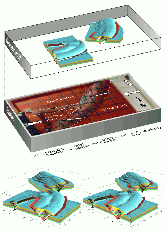
The reconstruction of the tectonic evolution of that region has been tested using analog experiments (Ebert et al. 1995). These have been carried out in a sandbox (62 x 35 x 6 cm) at the laboratory of CENPES/PETROBRAS (Rio de Janeiro). Three solid (plexiglass) plates on its base represent the shape of the continental plates (scale 1 : 2,500,000). The continental crustal thickness of 40 km is represented by 8 layers of quartz sand (grain size = 0.42 mm), each 2 mm thick. Initially 115 to 200 km wide basins were considered between the plates. The thinner crust of the basins is set up by only six layers, each 2 mm thick. The experiments simulated E-W compression which lead to the closure of the basins. First, the São Paulo Block moved against the Brasília Block from west to east and then the Vitória Block collided against both from east to west (Figure 5). The amount of shortening, shear strain and displacement was measured along each of the three branches for the different stages of the experiment.
The subject of this paper is the development of a 3D geometric model to represent the deformation structures produced by the analog modeling. The regional tectonic structures were compared with the experimentally developed structures using the dynamic visualization techniques on a graphic workstation.
Geometric Modeling
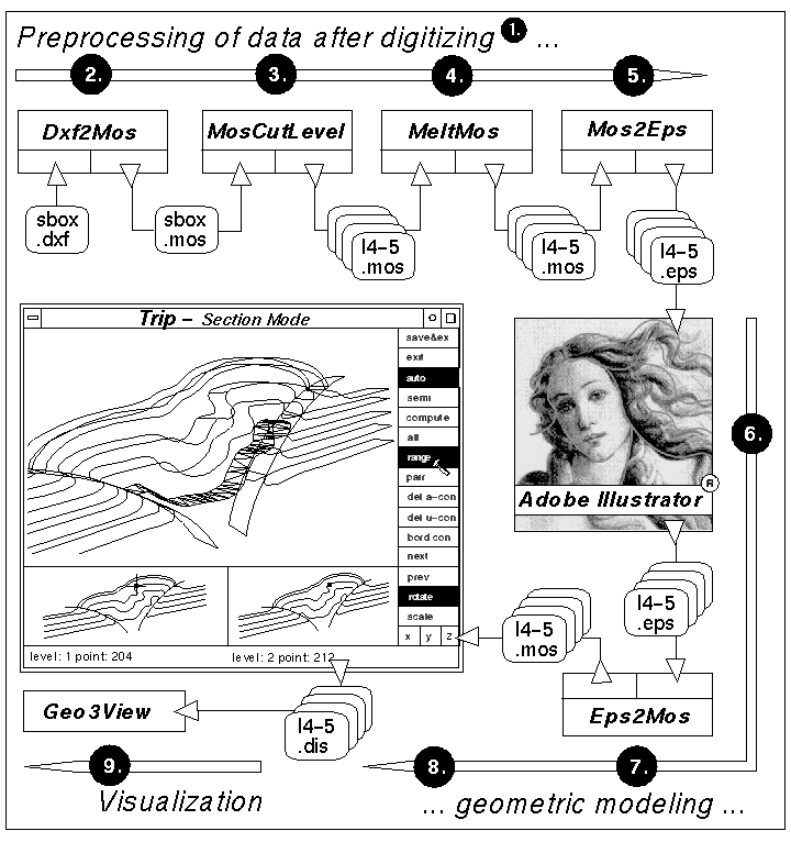
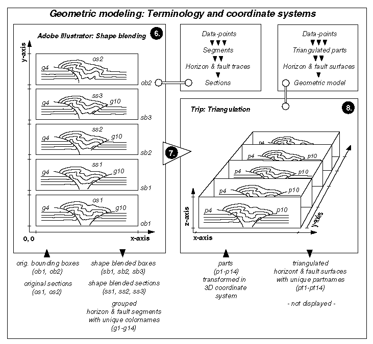
When the the shortening experiment was finished, the sandbox model was cut perpendicular to the plate boundaries. Photographs of the sections were taken. Five layers and the related faults were digitized. Two sets of sections were taken from different subvolumes of the sandbody. The reconstruction of boundary surfaces from serial sections is an already established technique in the field of geometric modeling (Klein et al. 1989). If sections are connected directly various problems will be encountered (e.g. the pinching out of horizons and the termination of faults between sections). One possible solution described here is the construction of additional sections between the original ones. This can be done manually using overlays. We have established a computer-supported method to interpolate sections by combining the shape blending and manual editing in problematic areas. Preprocessing of data and geometric modeling is carried out in steps (see below). Figure 1 gives an overview of dataflow involved. All programs except Adobe Illustrator® and AutoCAD® were developed by the computing group at the Geological Institute Freiburg in the C programming language.
Step 1: Sections of the sandbox experiment were digitized with AutoCAD.
Step 2: Converting the resulting AutoCAD DXF file into the MOS format (Christiansen 1986) by a program called Dxf2Mos.
Step 3: Separation of each digitized section from the MOS file containing all the sections. A filter developed for this procedure is called MosCutLevel.
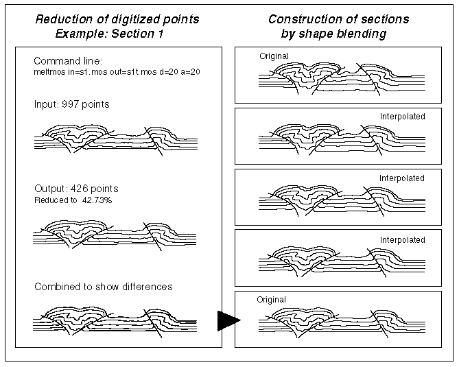
Step 4: A common problem is caused by the far too high point-sampling rates produced while digitizing the lines. The program MeltMos was developed to reduce point density while maintaining the curvature of the sampled line segment. Figure 3 shows an example of the data-point reduction of over 50%. Overlaying the original and processed sections (Figure 3, lower section) demonstrates the small amount of change in geometry. This reduction improves the result of the subsequent triangulation.
Step 5: The reduced section MOS files are prepared using Adobe Illustrator (AI). For this purpose, they are converted into encapsulated PostScript® (EPS) by the program Mos2Eps.
Step 6: Using AI the sections are edited, arranged and interpolated. Editing the original section data includes the elimination of typical misfit at the end of the segments. Minor changes of sampling intervals are performed to meet the pre-requisites of the smooth-mesh generation in step 8. Working on vector data can be effectively organized in AI. Hotkeys reduce the point and click interaction (e.g. switching the viewport between overview and details). We used the built-in shape blending feature in AI called the blend tool to interpolate segments between the given sections. Figures 2 and 3 show the generation of three interpolated sections between two original sections. For visibility reasons the original sections are displaced to the top and bottom of the AI page. The first shape blending produced three bounding boxes between the given sections. They are used for transforming data later on (Figure 2). Not all sections allow a straight-forward morphing between two matching segments. Where faults terminate or branch we had to interpolate manually. To meet the part concept of the MOS files we had to find a way to characterize the related segments through out the sections. An easy-to-handle attribute of a segment is its color. AI allows to set user-defined colornames, such as 'part1', 'part2' and so on. AI's grouping capabilities were used to make sure that all segments defined by the same colorname were stored in one sequence within the EPS file.
Step 7: The path back from encapsulated PostScript to the MOS format is necessary to develop the boundary surfaces described in the next step. The PostScript code is interpreted by a program called Eps2Mos. The former grouped blocks of segments were stripped from the EPS file and written as numbered parts into the MOS file. The part number was identified by the AI colorname. All point coordinates were transformed according to the bounding box that circumscribes the current segment (Figure 2). The result was written as a stack of sections (with the originally digitized orientation) to the MOS file.
Step 8: The set of sections was loaded into the program Trip (a triangulation program). It was developed in C and uses the X11 window system for graphic interaction capabilities. Trip implements different schemes to connect data points by triangulation. By connecting horizon and fault traces through a frame of sections, a boundary represented geometric model was produced. The algorithm to triangulate between parallel sections is based on the Fortran program Sectio (Tipper 1977). Trip follows a part concept. We have implemented this concept to handle sections containing several faulted horizons. Starting with the first section all points of the first part will be connected with triangles to the corresponding part on the following section until the last section is reached. Then the next part is processed through all sections. Trip displays the whole data set -or any part of it- color coded in three windows (Figure 1). The triangulation can be controlled by user interaction. The smaller subwindows allow setting of connections between selected points on adjacent sections. The triangulation follows these constraints. This is a fast method to obtain nearly equi-lateral triangles also in the problematic areas of the surface. To control the triangulation process the model is displayed in a wireframe representation. No hidden line algorithm is implemented but the viewpoint can be changed to any position around the model. After triangulation of all horizons and faults the meshes were stored in DIS files (Christiansen 1986). This concludes the geometric modeling procedure.
Visualization
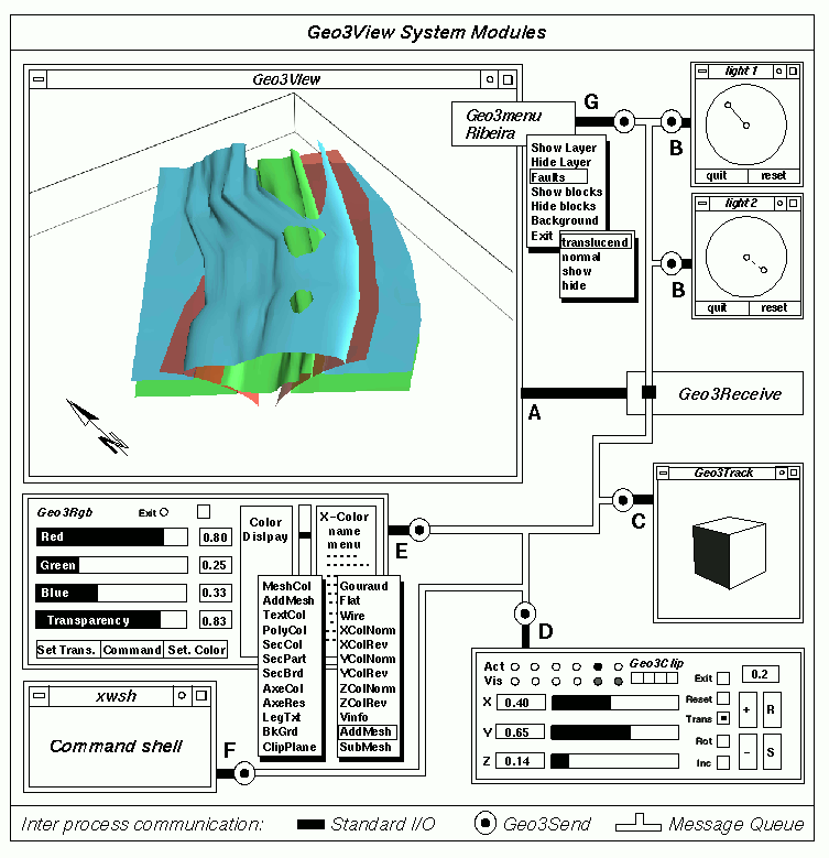
Once the boundary represented geometric model of the deformed sandbody was derived, it was visualized within the Geo3View program system (Klein & Ramshorn 1991, Lindenbeck & Ulmer 1995). The meshes of all horizons and faults are displayed as shaded solid surfaces (Figure 4a). To obtain a 3D impression of the surfaces, several lightsources (Figure 4b) can be placed at various positions around the model. The shading is calculated using the direction and intensity of the lights. The resulting variation of brightness on the surface improves the 3D impression. The viewpoint can be changed interactively by rotating a camera around the model (Geo3Track, Figure 4c). Using modern graphic workstations, up to several 100,000 triangles can be shaded in a second. This allows a dynamic visualization of the model in real time. A dynamic investigation of an unknown structure is much clearer than looking at static figures. Movement is comparable to viewing a static stereoscopic model which enables intuitive depth perception 'inside' the geometric model. Such a stereoscopic model view is shown in Figure 5. An important visualization technique also implemented in Geo3View are clipping planes (Geo3Clip, Figure 4d). By moving up to six clipping planes interactively through the model, any subvolume of the structure can be examined in detail. Different attributes (color, transparency) can be given to all parts of the model (Geo3Rgb, Figure 4e). All parts or groups can be shown and separately hidden. Geo3View is based on a command language (Command shell, Figure 4f). Groups of commands or command scripts can be arranged in a model-specific menu (Geo3Menu, Figure 4g).
Discussion of results
The aim of the physical modeling was to analyze the relations between strike-slip shearing and simultaneous contraction during oblique convergence of three plate margins of different orientation to the convergence vector. The deformation structures produced by the horizontal, non-coaxial strain component were recognized on the surface of the sandbox as dextral (NE-SW branch) and sinistral (E-W branch) strike-slip shear zones displacing a perpendicular grid (Figure 5). The simultaneous shortening component of the strain along the three branches between the plate margins is recognized in cross-sections. They are well visualized in the computerized geometric models and reflect the transpressional regime deduced from field investigations.
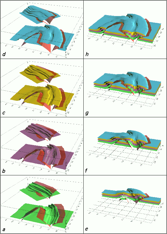
Figures 5 and 6 show shortening of layers accommodated by folding and thrusting. There is a complex geometric relationship between contemporaneously folded and faulted layers. Along strike there is a lateral transition of folds with decreasing interlimb angle. The fold limbs become disrupted and thrust fault planes along their axial plane are developed.
Along the east-west and the northern branches where only one of the plates was moving against the fixed Brasília Block, the contractional structures (folds and overthrusts) are asymmetric. In the corresponding northern Ribeira belt and in the E-W striking Campo do Meio shear belt a strong vergence of the regional structures against the São Franscisco Craton is also characteristic. Along the southern branch, where São Paulo and Vitória Blocks obliquely converged against each other, two parallel systems of shear zones with opposite dipping directions are pronounced (Figures 5 and 6). They have oblique strike-slip and thrust character, being separated by a large synformal fold. They correspond kinematically to large, ductile, positive flower structures observed in the transpressional Rio Paraíba do Sul shear belt (Ebert et al. 1996). A lower degree of vergence is also characteristic there. On the regional scale, as in the model, it is difficult to distinguish from the dip directions alone between the thrusts and the backthrusts (synthetic to the subduction direction). Frontal subduction or to northwest or to southeast has been assumed by different workers (Almeida & Hasui 1984).
In the experiment, as well-recognized in the computer model, the synformal folds are delimited from antiformal structures by fault planes. This partitioning due to the transpressional regime is well observed in regional scale where folds are intercalated with contemporaneous subparallel strike-slip shear zones (Ebert et al., op. cit.). Until recently, these distinct structural styles have been ascribed to different regional tectonic events (frontal thrust-fold belts due to NW-SE plate convergence overprinted by younger strike-slip shear zones).
The structural bifurcation around the São Paulo Block corresponds regionally to the Guaxupé Syntaxis. It is a regional, triangular shaped and synformal structure. The eastern nose of the Guaxupé Syntaxis does not correspond to an indentation wedge. This would have produced a much stronger crustal thickening in this area (in the field and in the experiment). The sandbox model demonstrates this regional structure as the superposition of two transpressional shear belts produced by the collision between three plates.
The dynamic visualization of the boundary represented geometric model improves the analysis of the structures produced by the physical experiment. It helps to demonstrate that the geometric and kinematic parameters obtained from field investigations and applied in the analog experiment, yielded a structural framework which is coherent with the observations on the regional scale.
References
Almeida, F.F.M. de Christiansen, Ebert, H.D., Ebert, H.D. Ebert, H.D., Hasui, Y. Klein, H., Klein, H Lindenbeck, Ch. Tipper, J. C.
The amount of figures and photo plates was limited here. To get a closer view, visit the Web-Server at the Freiburg Geological Institute. The URL is http:\\www.geologie.uni-freiburg.de. You will find this project under the topic 'Paper and Abstracts'. There are several model views and animated sequences (MPEG format) ready for downloading. The conversion of the surfaces to VRML (the Internet 3D exchange format) is in preparation.
MOS format (Mosaic) and DIS format (Display) were developed by MOVIE.BYU Group (Christiansen 1986). Adobe Illustrator® and PostScript® are registered trademarks of Adobe Systems Incorporated. AutoCad® is a registered trademark of Autodesk Development B.V.
Fig 2: Geometric modeling steps 6-8 (see text for details). Interpolation of sections (shape blending, step 6) is followed by triangualation of the surfaces (step 8). The different coordinate systems are transformed by Eps2Mos (step 7). Upper right: Hierarchical subsets of the model and related terminology.
Fig. 3: Left: Processing of the oversampled digitized section with the program MeltMos. Upper section shows original data. The number of data points in the middle section is halfed. Lower section shows input and output overlayed to visualize the minor differences in geometry.
Right: Interpolation of additional sections using Adobe Illustrator. The three middle sections (entitled interpolated) are the result of shape blending between the two given sections (section 1 and 5).
Fig. 4: Schematic diagram of the Geo3View program system. The main program (A) and the user interface programs (B-G) communicate through a UNIX message queue managed by Geo3Send (circles) and Geo3Receive. The graphic window shows two horizons. The upper horizon is partially clipped by a horizontal plane.
Fig. 5: Middle: Perspective view of the sandbox experiment. After simulation of an E-W collision of the Vitória and São Paulo Block against the Brasília Block. The initial and final positions of three pointpairs along each branch reveal the relative strike-slip displacement between the plate boundaries. Shown above are the two subvolumes of the shaded geometric model vertically displayed relative to the experiment. Lower picture: A stereoscopic view from WSW.
Fig. 6: Perspective views of the shaded geometric model from WSW. Pictures a-d show the deformation style of different horizons, which are shortened by folds and oblique inverse faults. Sequence e-h is generated by a N-S striking clipping plane moving from west to east, respectiveley, through the model. The divergent pattern forms a positive flower structure in regional scale. The wedge shaped structure corresponds to the Guaxupé Syntaxis.
HomePage Geol. Inst. Freiburg | HomePage UNESP Rio Claro