in German
The goal of this project is the reconstruction of the flow
of interstitial water in the Southern German Molasse Basin
during the basin development, using a flow and transport
model. The changing salinities of the depositional environment
have a special significance: The marine deposits of the UMM
(Upper Marine Molasse) originally contained saline intestitial
water, which is presently observed in the underlying LFM
(Lower Freshwater Molasse). The modeling results will be
verified using the saline interstitial water as a tracer. In
addition, the recent hydraulic properties (hydraulic
conductivity, specific storage, porosity) of each Molasse
layer have to be matched.
For comparison, the recent values of these parameters were
determined from numerous wells with support of oil companies
which have been active in the Molasse Basin and the GLA
Baden-Württemberg (Geological Survey of
Baden-Württemberg). The results of the modeling allow
certain
conclusions to be drawn about the extent of consolidationally
and topographically induced flow of interstitial waters in the
Molasse Basin and about the timing of the hydraulic connection
of the River Danube to the Molasse flow-system.
In the last years, there have been various attempts to
model the flow of interstitial waters and paleocurrent regimes
of extended sedimentary basins over a geological large period
of time by computer programs. The movement of interstitial
waters is mainly due to topographic and consolidational
flow. The software programs therefore had to be able to
combine these different processes. The simulation models were
based on the numeric solutions of the flow and transport
equations (e.g. Kinzelbach 1986, Bitzer
1994, Bitzer 1996). The flow of interstitial water can
lead to a change in the sediment composition by fluid-rock
interaction and thereby contribute to the development of
hydrocarbon reservoirs (Sachsenhofer, 1994) or ore deposits
(Garven & Freeze, 1984).
Because an exact knowledge of the recent hydraulic
conditions and characteristics of each sedimentary layer are
necessary for a computer simulation, the most suitable
sedimentary basins for simulation are the ones in which a
large number of wells exist. Examples for the calculation of
the paleocurrent regime along a 2D cross-section through an
extensive sedimentary basin are given by Bachu (1995) for the
Canadian Alberta Basin and by Lee & Bethke (1994) for the
American Denver Basin.
In Central Europe, the Southern German Molasse Basin is
also suitable for computer simulation, because a large number
of oil- and thermal wells have been drilled. In the western
part of the Molasse Basin, the well data of 150 wells is
available and can be used for the project by permission of the
oil companies. With the hydraulic characteristics taken from
well-log interpretation (porosity, hydraulic conductivity,
specific storage, compressibility) the paleocurrent-regime of
the Molasse Basin can be modeled. The results of the modeling
will allow certain conclusions to be drawn about the extent of
consolidationally und topograghically induced flow of
interstitial
waters in the Molasse Basin, about the timing of the hydraulic
connection of the River Danube to the Molasse flow-system and
about the timing of the karstification of the Malm limestones.
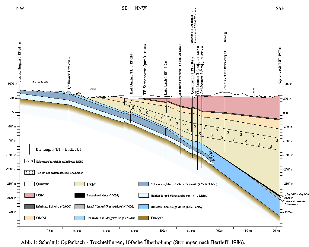
Using the data taken from well-log interpretations and data from previous work (e.g. Bertleff, 1986; Bertleff et al. 1988; Keller, 1992; Schmassmann, 1990; Stober, 1984; Villinger, 1977) a representative cross-section through the Molasse Basin has been constructed, which serves as a framework of the simulation (Figure 1).
The changing salinity of the depositional environment has a
special significance: The marine deposits of the UMM
originally contained saline interstitial water, which is
presently observed in the underlying LFM (Lemcke & Tunn, 1956,
Udluft, 1975; Lemcke, 1976). This indicates that an at least
temporarily downward flow of water occured during the past 20
Ma. The saline interstitial water can therefore be seen as a
marker for the verification of the model.
Using the available data, a data bank has been compiled which was then used for calculations with the simulation- program BASIN written by K. Bitzer in Fortran77.
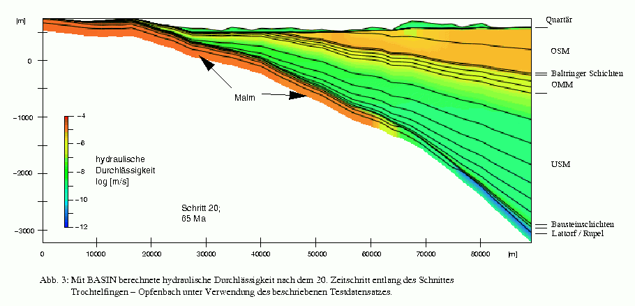
Figure 2 and 3 show the development of the hydraulic conductivity after simulation. The 91km cross-section Trochtelfingen - Opfenbach is subdivided into 50 segments, each segment 1820m wide. The first layer corresponds to the underlying Malm. The deposition of the Molasse layers is simulated in 16 timesteps (second to 17th timestep = layers). The last three timesteps (18th to 20th layer) correspond to the Late Tertiary uplift and erosion of the Molasse Basin. Figure 2 shows snapshots of the development of the hydraulic conductivity with the program Geo3View (Klein & Ramshorn, 1991; Lindenbeck & Ulmer, 1995) after every 4th timestep. The final situation (20th timestep) is reproduced in Figure 3. The different formations of the Molasse are marked along the right edge of Figure 3. The additional subdivision of the stratigraphy within Figure 3 reflects the number of input layers. Compared to Figure 1, a remarkable correspondence of the thickness of the layers and the depth of the formation boundaries can be seen. In addition, the calculated values of the hydraulic conductivities correspond to recently measured values. Conclusions can therefore be drawn about the initial sediment thicknesses and the final uplift of the basin.
In the same way, it is possible to calculate the parameters
hydraulic head, temperature, TT-index, porosity and specific
storage during the development of the Molasse Basin using the
Program BASIN. The results can be reproduced as animations
within Geo3View.
The goal of the project is the reconstruction of the flow of interstitial water in the western part of the Southern German Molasse Basin taking into consideration the consolidational and topographic flow components.
to the Homepage of the Geological Institute