Research concerning the preliminary subject of my PhD-Thesis: Structure, kinematics and mechanics of a low-angle detachment-fault - Western Woodlark Basin (ODP Leg 180)
The accomplishment of the project-work is planned for a timespan of three years (August 1998 - July 2001) and is financed by the Deutsche Forschungsgemeinschaft (DFG).
Background:
ODP-Leg 180 is located/situated in the western Woodlark Basin, where backarc-spreading associated to the Trobriand subduction zone in the north accounts for Pliocene-Pleistocene ocean-spreading successively propagating to the west into the continental crust underlying Papua Newguinea, causing there continental rifting. In this zone just north-west of the oceanic spreading tip, the incipient continental extension is accomodated by recently active low-angle normal-faulting (evidence by earthquake source data).
Moresby Seamount, a topographic high, builds the uplifted footwall of a north-northeasterly dipping (with 25-30°) low-angle detachment-fault which can be traced by seismic profiles to a depth of 9km in basement rocks and under flexured prerift sediments and unconformably onlapping synrift sediments of the hanging wall.
Several sites were drilled along seismic profiles at Moresby Seamount and the adjacent area aiming to get direct and indirect information from borehole logging/measurements and investigations on rock samples about the conditions enabling relative movement of the lithospheric blocks subjected to faulting at the main detachment and minor associated fault planes.
Samples:
Samples providing structural features stem directly from the fault zone and the nearer environment of the hanging- and footwall. The deformation style varies from brittle to ductile with overprinting of structures in both directions resulting of exhumation of the footwall by unloading and of burying of the hangingwall by relative downward movement and increasing sediment load.The footwall rocks show more intense deformation than the hangingwall rocks do.
The hangingwall rocks present in the disposable samples consist mainly of fine to coarse grained syn- and pre-rift sediments beeing detritus of volcanic and igneous basement rocks of different alteration and metamorphic stages. Remarkable are the talus sites with gravitationally transported blocks of different size laying in finer grained matrix both derived from the exhumed footwall. The footwall samples consist mainly of basic igneous rocks of greenschist metamorphic grade also differently alterated.
The fault zone itself consists of intensely brecciated material, of ultracataclastic fault gouge.
Aims/Strategy:
Qualitative and quantitative analysis of meso- and microscopic structural fabrics and deformation indicators with optical microscope, Scanning electron microscope (SEM) and Transmission electron microscope (TEM), depending on adequate methods for the different rock types and the features to be studied (filled veins and microfaults, Quartz c-axes orientation, intra- and intercrystalline deformation as dislocation glide, Calcite twinning, pressure solution, recristallisation, crystalplastic flow, etc)
Contemporaneously , further gained data concerning rock properties (porosity, permeability, mechanic properties, etc) and borehole data (temperature, pore-water chemistry) are to be compiled to finally derive a consistent understanding about the deformation history and related mechanic and kinematic evolution of the low-angle detachment fault.
Figures :
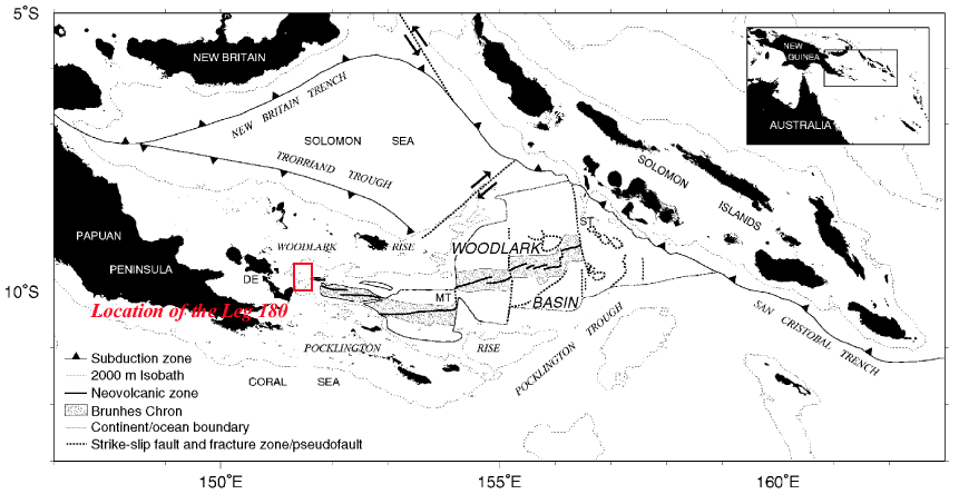
I) Major physiographic features and active plate boundaries of the Woodlark Basin region. The stippled area encloses oceanic
crust formed during the Brunhes Chron at spreading rates (labeled in mm/yr). MT and ST = Moresby and Simbo transform faults,
respectively; DE = D'Entrecasteaux Islands. Inset, geographical location of the Woodlark Basin
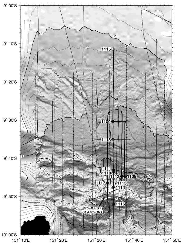
II) Shaded relief map showing the locations of the Leg 180 drill sites and multichannel seismic tracks, plotted on a base map with
200-m bathymetric contours (thicker contours labeled every kilometer).